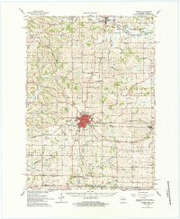
1962 Map of Monroe
USGS Topo · Published 1984About this map
Monroe serves as the bustling commercial and transportation hub of Green County in this early 1960s survey, defined by its concentration of rail infrastructure and civic institutions. The tracks of the Chicago Milwaukee St Paul and Pacific and the Illinois Central railroads converge here, supporting the agricultural economy of the surrounding townships. Beyond the city limits, the landscape is organized by a dense network of rural schools and churches that speak to the established dairy farming communities of the era. Significant landmarks include the County Farm and the Monroe Municipal Airport, while the smaller settlements of Monticello, Juda, and Clarno anchor the outlying districts. The terrain is deeply etched by a complex drainage system featuring the Sugar River and Little Sugar River, which are fed by numerous family-named branches like Hammerly Cr and Burgy Creek. Numerous quarries and gravel pits scattered across Mount Pleasant and Sylvester townships indicate a landscape actively utilized for its local mineral resources.
Find a feature on this map
89 named features on this map. Tap any name to fly to it.
Don’t see what you’re looking for? This feature index may not catch every label — zoom into the map to look around manually.
Map Details
Editions of this 1962 Monroe Map
2 editions found
Other maps of this area

1889 · Evansville
USGS Topo · 1:62,500

1893 · Brodhead
USGS Topo · 1:62,500

1894 · Evansville
USGS Topo · 1:62,500

1906 · Evansville
USGS Topo · 1:62,500

1920 · Monroe
USGS Topo · 1:62,500

1922 · Monroe
USGS Topo · 1:62,500

1923 · Blanchardville
USGS Topo · 1:62,500

1923 · New Glarus
USGS Topo · 1:62,500

1923 · South Wayne
USGS Topo · 1:62,500

1932 · Pecatonica
USGS Topo · 1:62,500