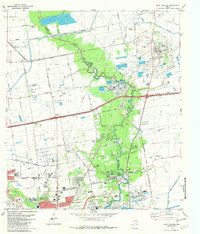
1982 Map of Mont Belvieu
USGS Topo · Published 1982About this map
Mont Belvieu and the industrial landscape of the western Gulf Coast define this early 1980s topographical survey at the Harris Co Chambers Co line. The map highlights the significant infrastructure supporting the local Oil and Gas Field, featuring a dense network of pipelines, storage tanks, and the massive refinery and powerplant complexes near Baytown. Water management is central to the area's development, evidenced by the Barbers Hill Canal (Elevated) and the winding course of Cedar Bayou, which separates the industrial zones from established residential centers. For researchers of local history, the map preserves the locations of numerous family and community landmarks, including the Busch Cem, Fisher Cem, and Morgan Cem, alongside civic institutions like Sterling High Sch and Church Jr High Sch. The transition from the rural Barbers Hill salt dome to the expanding urban footprint of Baytown is clearly visible through the evolving road network.
Find a feature on this map
55 named features on this map. Tap any name to fly to it.
Don’t see what you’re looking for? This feature index may not catch every label — zoom into the map to look around manually.
Map Details
Editions of this 1982 Mont Belvieu Map
This is the sole edition of this map. No revisions or reprints were ever made.
Other maps of this area

1916 · Burnett Bay
USGS Topo · 1:24,000

1916 · Crosby
USGS Topo · 1:24,000

1916 · Morgan Point
USGS Topo · 1:24,000

1916 · Cedar Bayou
USGS Topo · 1:24,000

1916 · La Porte
USGS Topo · 1:24,000

1919 · Morgan Point
USGS Topo · 1:31,680

1919 · Crosby
USGS Topo · 1:31,680

1919 · Cedar Bayou
USGS Topo · 1:31,680

1920 · La Porte
USGS Topo · 1:31,680

1920 · Highlands
USGS Topo · 1:31,680