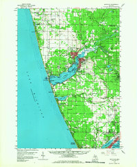
1959 Map of Montague
USGS Topo · Published 1968About this map
The twin cities of Montague and Whitehall anchor this Lake Michigan coastal landscape, situated where the White River flows into the expansive White Lake. During the late 1950s, the region supported a dense network of rural infrastructure, including numerous family-named schools such as Conklin Sch, McMillan Sch, and the Laketon Schools. The shoreline transitions from the dunes near Sylvan Beach and Wabaningo to the inland waters of Duck Lake and Muskrat Lake. A distinct transportation corridor is formed by the Chesapeake and Ohio railroad, which parallels the coast and serves the industrial and residential hubs of South Whitehall and Berry Junction. Significant public lands like the Manistee National Forest and Muskegon State Park mark the preservation of the lakefront, while smaller landmarks like Sadony Bayou and Indian Point highlight the irregular geography of the river mouth.
Find a feature on this map
80 named features on this map. Tap any name to fly to it.
Don’t see what you’re looking for? This feature index may not catch every label — zoom into the map to look around manually.
Map Details
Editions of this 1959 Montague Map
2 editions found

Other maps of this area

1929 · Montague
USGS Topo · 1:48,000

1930 · Lake Harbor
USGS Topo · 1:48,000

1930 · Muskegon
USGS Topo · 1:62,500

1931 · Hart SE
USGS Topo · 1:31,680

1931 · Walkerville SW
USGS Topo · 1:31,680

1936 · Muskegon
USGS Topo · 1:62,500

1936 · Lake Harbor
USGS Topo · 1:62,500

1954 · Milwaukee
USGS Topo · 1:250,000

1958 · Milwaukee
USGS Topo · 1:250,000

1958 · Hesperia
USGS Topo · 1:62,500