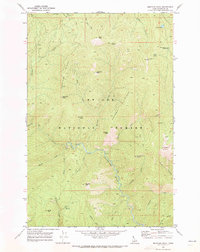
1969 Map of Montana Peak
USGS Topo · Published 1973About this map
St Joe National Forest dominates this topographic study of the Shoshone County interior, where high ridgelines and deep river drainages define the landscape. The Little North Fork Clearwater River winds through the southern half of the quadrangle, notably featuring a Ford at the junction of Mink Creek and Stubtoe Creek. Strategic high points are marked by Snow Peak L.O. and Montana Peak, which along with Hoodoo Peak and Bear Skull, served as primary landmarks for navigation and fire monitoring.
Find a feature on this map
35 named features on this map. Tap any name to fly to it.
Don’t see what you’re looking for? This feature index may not catch every label — zoom into the map to look around manually.
Map Details
Editions of this 1969 Montana Peak Map
This is the sole edition of this map. No revisions or reprints were ever made.
Other maps of this area

1914 · Avery
USGS Topo · 1:125,000

1917 · Avery
USGS Topo · 1:125,000

1923 · Washington Creek
USGS Topo · 1:125,000

1936 · Boehls Butte
USGS Topo · 1:48,000

1943 · Boehls Butte
USGS Topo · 1:62,500

1956 · Wallace
USGS Topo · 1:250,000

1956 · Hamilton
USGS Topo · 1:250,000

1959 · Hamilton
USGS Topo · 1:250,000

1960 · Wallace
USGS Topo · 1:250,000

1960 · Hamilton
USGS Topo · 1:250,000