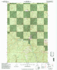
1995 Map of Montana Peak
USGS Topo · Published 1997About this map
Montana Ridge defines the high-altitude backbone of this Idaho landscape within the St Joe National Forest. This 1990s-era revision shows a region dominated by sharp relief and vital water sources, where the North Fork St Joe River winds through the lower elevations fed by numerous named drainages like Butte Creek and Skull Creek. The terrain is punctuated by significant summits including Montana Peak and Hoodoo Peak, providing a clear record of the area's topographical structure.
Find a feature on this map
28 named features on this map. Tap any name to fly to it.
Don’t see what you’re looking for? This feature index may not catch every label — zoom into the map to look around manually.
Map Details
Editions of this 1995 Montana Peak Map
This is the sole edition of this map. No revisions or reprints were ever made.
Other maps of this area

1914 · Avery
USGS Topo · 1:125,000

1917 · Avery
USGS Topo · 1:125,000

1923 · Washington Creek
USGS Topo · 1:125,000

1936 · Boehls Butte
USGS Topo · 1:48,000

1943 · Boehls Butte
USGS Topo · 1:62,500

1956 · Wallace
USGS Topo · 1:250,000

1956 · Hamilton
USGS Topo · 1:250,000

1959 · Hamilton
USGS Topo · 1:250,000

1960 · Wallace
USGS Topo · 1:250,000

1960 · Hamilton
USGS Topo · 1:250,000