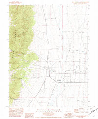
1982 Map of Monte Neva Hot Springs
USGS Topo · Published 1982About this map
Monte Neva Hot Springs sits at the heart of this landscape, characterized by the geothermal features and water management systems required in the high desert of White Pine County. The area east of the Egan Range shows a complex network of Ditch and Ditches, including Ditch I and Ditch P, which divert waters from Duck Creek and Mattier Creek across the Steptoe Valley. These man-made watercourses support the Corrals and agricultural interests near the settlement of Fitzhugh. To the west, the terrain rises sharply into a series of deeply carved drainages such as Pluto Canyon, Rattlesnake Canyon, and Boneyard Canyon, where Ruins and scattered Springs hint at earlier habitation or livestock operations. The presence of Cooling Settling Ponds near the main hot springs indicates the industrial utilization of the natural thermal waters during this era.
Find a feature on this map
35 named features on this map. Tap any name to fly to it.
Don’t see what you’re looking for? This feature index may not catch every label — zoom into the map to look around manually.
Map Details
Editions of this 1982 Monte Neva Hot Springs Map
This is the sole edition of this map. No revisions or reprints were ever made.
Other maps of this area

1956 · Ely
USGS Topo · 1:250,000

1959 · Ely
USGS Topo · 1:250,000

1963 · Ely
USGS Topo · 1:250,000

1982 · Borchert Spring
USGS Topo · 1:24,000
1982 · Steptoe Ranch
USGS Topo · 1:24,000
1982 · Steptoe
USGS Topo · 1:24,000
1982 · Schellbourne
USGS Topo · 1:24,000
1982 · Telegraph Peak
USGS Topo · 1:24,000
1982 · Mattier Creek
USGS Topo · 1:24,000
1982 · Egan Canyon
USGS Topo · 1:24,000