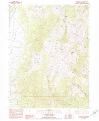
1982 Map of Telegraph Peak
USGS Topo · Published 1982About this map
Telegraph Peak dominates this high-altitude landscape of White Pine County, where the high ridges of the Egan Range and Cherry Creek Range flank the broad expanse of Butte Valley. The map documents a working livestock landscape in the early 1980s, evidenced by the Telegraph Shearing Corrals and Quakies Sheep Camp. These labels, along with scattered Prospects and a Borrow Pit, highlight the traditional regional reliance on ranching and mineral exploration. Water is the primary driver of placement here, with numerous named sources such as Billy Pope Spring, Mustang Spring, and Hunter Springs dotting the drainages. These springs often correspond with small clearings like Frenchy Meadows or remnants of human activity, including unidentified Ruins and the uniquely named April Fool Spring. The terrain is carved by steep passages like Telegraph Canyon and Boneyard Canyon, illustrating the challenging geography of the Great Basin's basin-and-range province.
Find a feature on this map
32 named features on this map. Tap any name to fly to it.
Don’t see what you’re looking for? This feature index may not catch every label — zoom into the map to look around manually.
Map Details
Editions of this 1982 Telegraph Peak Map
This is the sole edition of this map. No revisions or reprints were ever made.
Other maps of this area

1956 · Ely
USGS Topo · 1:250,000

1959 · Ely
USGS Topo · 1:250,000
1962 · Hunter Point
USGS Topo · 1:24,000

1963 · Ely
USGS Topo · 1:250,000

1982 · Borchert Spring
USGS Topo · 1:24,000
1982 · Franks Well
USGS Topo · 1:24,000
1982 · Monte Neva Hot Springs
USGS Topo · 1:24,000
1982 · Steptoe Ranch
USGS Topo · 1:24,000
1982 · Steptoe
USGS Topo · 1:24,000
1982 · Egan Canyon
USGS Topo · 1:24,000