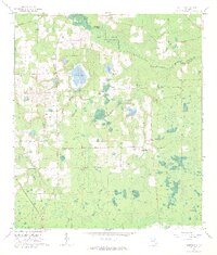
1966 Map of Monteocha
USGS Topo · Published 1967About this map
The Santa Fe River forms a natural boundary between Bradford and Alachua Counties in this mid-1960s snapshot of North Central Florida. The landscape is defined by the expansive Mud Swamp and numerous smaller water bodies like Sunshine Lake and Trout Pond, illustrating the region's complex hydrology. This period of development is marked by the presence of the Seaboard Coast Line railroad and a network of firebreaks and pipelines cutting through the timber and wetlands.
Find a feature on this map
24 named features on this map. Tap any name to fly to it.
Don’t see what you’re looking for? This feature index may not catch every label — zoom into the map to look around manually.
Map Details
Editions of this 1966 Monteocha Map
2 editions found
Other maps of this area

1890 · Arredondo
USGS Topo · 1:62,500

1892 · Arredondo
USGS Topo · 1:62,500

1894 · Arredondo
USGS Topo · 1:62,500

1938 · Hawthorn
USGS Topo · 1:48,000

1941 · Starke
USGS Topo · 1:62,500

1943 · Hawthorn
USGS Topo · 1:62,500

1948 · Starke
USGS Topo · 1:50,000

1949 · Sampson
USGS Topo · 1:24,000

1949 · Waldo
USGS Topo · 1:24,000

1949 · Starke
USGS Topo · 1:62,500