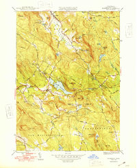
1948 Map of Monterey
USGS Topo · Published 1948About this map
The Tyringham Valley serves as a prominent corridor through this Berkshire landscape, where the Appalachian Trail winds over the northern ridges near Sky Hill and Cobble Hill. This 1940s survey reveals a region defined by its reliance on the Konkapot River and its tributaries, which connect a series of small, high-elevation communities. The village of Monterey sits centrally at the edge of Lake Garfield, while to the east, West Otis is surrounded by a dense network of water features including Hayes Pond and Phelps Swamp. Local religious and community life is anchored by landmarks such as Our Lady of the Hills Chapel and the New England Keswick Ch. The map also captures significant rural holdings and family-named landmarks like Gould Farm and Hephzibah Heights, along with early burial grounds including Old Center Cem and Woods Cem, providing a window into the settled history of these mountain townships.
Find a feature on this map
62 named features on this map. Tap any name to fly to it.
Don’t see what you’re looking for? This feature index may not catch every label — zoom into the map to look around manually.
Map Details
Editions of this 1948 Monterey Map
2 editions found

Other maps of this area

1885 · Sheffield
USGS Topo · 1:62,500

1886 · Becket
USGS Topo · 1:62,500

1888 · Sheffield
USGS Topo · 1:62,500

1888 · Becket
USGS Topo · 1:62,500

1888 · Sandisfield
USGS Topo · 1:62,500

1888 · Pittsfield
USGS Topo · 1:62,500

1890 · Pittsfield
USGS Topo · 1:62,500

1891 · Sheffield
USGS Topo · 1:62,500

1893 · Becket
USGS Topo · 1:62,500

1893 · Sheffield
USGS Topo · 1:62,500