
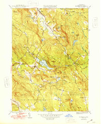
1948 Map of Monterey
USGS Topo · Published 1948About this map
The Appalachian Trail winds through the northwestern corner of this Berkshire County landscape, crossing high points like Sky Hill and Cobble Hill before descending toward the village of Tyringham. This 1948 survey reveals a terrain defined by narrow valleys and numerous high-elevation ponds and swamps, including Shaker Pond and the sprawling Lake Garfield at the heart of Monterey. The settlement patterns here reflect a mix of traditional New England farming and specialized institutions, such as the Gould Farm and the Our Lady of the Hills Chapel.
Find a feature on this map
67 named features on this map. Tap any name to fly to it.
Don’t see what you’re looking for? This feature index may not catch every label — zoom into the map to look around manually.
Map Details
Editions of this 1948 Monterey Map
2 editions found
Other maps of this area

1885 · Sheffield
USGS Topo · 1:62,500

1886 · Becket
USGS Topo · 1:62,500

1888 · Sheffield
USGS Topo · 1:62,500

1888 · Becket
USGS Topo · 1:62,500

1888 · Sandisfield
USGS Topo · 1:62,500

1888 · Pittsfield
USGS Topo · 1:62,500

1890 · Pittsfield
USGS Topo · 1:62,500

1891 · Sheffield
USGS Topo · 1:62,500

1893 · Becket
USGS Topo · 1:62,500

1893 · Sheffield
USGS Topo · 1:62,500