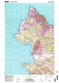
1997 Map of Monterey
USGS Topo · Published 2003About this map
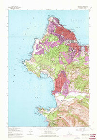
Monterey and its surrounding peninsula are captured here in a transition between their historic maritime roots and their development as a world-renowned coastal destination. The urban grid of Pacific Grove and New Monterey reaches toward the shoreline, where the Hopkins Marine Laboratory and the Lighthouse at Point Pinos reflect a legacy of science and navigation. Further south, the map illustrates the deliberate preservation of the coastline within the Point Lobos State Reserve, contrasting with the manicured grounds of the Golf Course and the winding route of Seventeen Mile Drive. The religious and educational foundations of the area are well-represented, from the Carmelite Mission and Mission San Carlos near Carmel By The Sea to the Stevenson Sch. Inland, the landscape shifts toward the hills of Pine Ridge and the Carmel River valley, where sites like Palo Corona Ranch and the Quarry denote a different style of land use.
Find a feature on this map
77 named features on this map. Tap any name to fly to it.
Don’t see what you’re looking for? This feature index may not catch every label — zoom into the map to look around manually.
Map Details
Editions of this 1997 Monterey Map
This is the sole edition of this map. No revisions or reprints were ever made.
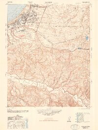
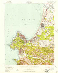
Other maps of this area

1913 · Monterey
USGS Topo · 1:62,500

1918 · Point Sur
USGS Topo · 1:62,500

1925 · Point Sur
USGS Topo · 1:62,500
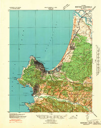
1941 · Monterey
USGS Topo · 1:62,500

1947 · Point Sur
USGS Topo · 1:62,500
1947 · Seaside
USGS Topo · 1:24,000
1947 · Monterey
USGS Topo · 1:62,500
1947 · Marina
USGS Topo · 1:24,000
1947 · Monterey
USGS Topo · 1:24,000

1948 · Santa Cruz
USGS Topo · 1:250,000