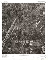
1975 Map of Montevallo NW
USGS Topo · Published 1977About this map
Cahaba River winds through the forested and industrial landscape of Shelby County in the mid-1970s. Produced in cooperation with the Soil Conservation Service, this orthophotoquad provides an unvarnished aerial view of the region's surface character. The imagery highlights extensive earth-moving operations and strip mining activities that contrast sharply with the surrounding dense woodland. While settlement names are absent from the labels on this specific sheet, the visual data clearly records the expansion of roads and small clearings that supported the local extractive economy and rural residential patterns during this period.
Find a feature on this map
1 named feature on this map. Tap any name to fly to it.
Don’t see what you’re looking for? This feature index may not catch every label — zoom into the map to look around manually.
Map Details
Editions of this 1975 Montevallo NW Map
This is the sole edition of this map. No revisions or reprints were ever made.
Other maps of this area

1890 · Bessemer
USGS Topo · 1:125,000

1892 · Bessemer
USGS Topo · 1:125,000

1899 · Brookwood
USGS Topo · 1:125,000

1905 · Bessemer Iron District
USGS Topo · 1:62,500

1907 · Bessemer Special
USGS Topo · 1:62,500

1910 · Montevallo
USGS Topo · 1:62,500

1927 · Adger
USGS Topo · 1:48,000

1932 · Yolande
USGS Topo · 1:62,500

1934 · Blocton
USGS Topo · 1:48,000

1935 · Yolande
USGS Topo · 1:62,500