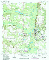
1971 Map of Montezuma
USGS Topo · Published 1986About this map
Montezuma and Oglethorpe anchor this riverine landscape, where the Flint River serves as the primary geographical divider between the two settlements. The rail network of the Seaboard and Southern lines dictates the local development, with tracks converging near the riverbanks. To the north, Whitewater State Park surrounds Whitewater Pond, a recreation area situated along the course of Whitewater Creek. The map documents a community deeply rooted in its local institutions, evidenced by the numerous country churches such as Mt Zion Ch and Hephzibah Ch. Educational and civic life is centered in the twin towns, featuring several schools like Douglas High Sch and multiple burial grounds including Felton Cem and the larger City Cem. The intricate network of waterways like Buck Creek and Beaver Creek feeds into the central river valley, defining the topography of central Macon County.
Find a feature on this map
38 named features on this map. Tap any name to fly to it.
Don’t see what you’re looking for? This feature index may not catch every label — zoom into the map to look around manually.
Map Details
Editions of this 1971 Montezuma Map
2 editions found
Other maps of this area

1955 · Phenix City
USGS Topo · 1:250,000

1957 · Phenix City
USGS Topo · 1:250,000

1957 · Macon
USGS Topo · 1:250,000

1958 · Macon
USGS Topo · 1:250,000

1958 · Phenix City
USGS Topo · 1:250,000

1964 · Macon
USGS Topo · 1:250,000

1971 · Ideal South
USGS Topo · 1:24,000

1971 · Ideal North
USGS Topo · 1:24,000

1971 · Garden Valley
USGS Topo · 1:24,000

1971 · Montezuma
USGS Topo · 1:24,000