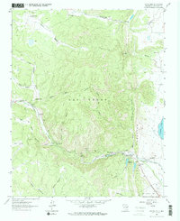
1961 Map of Montezuma
USGS Topo · Published 1965About this map
Montezuma sits at the foot of The Creston, where the high canyons of Sierrita La As Vegas meet the plains of San Miguel County. This early 1960s survey documents the transition from the high-desert drainages of Cañon del Agua and Cañon del Medio to the settled banks of Gallinas Creek. The presence of the Sagrario Corazon Ch and Gallinas Sch along the creek road points to a community-focused valley life, while the Peterson Reservoir and Storrie Lake Intake Canal show the critical infrastructure managing water for the region. To the south, Camp Maximiliano Luna and small clusters like El Llano and Los Vigiles further anchor the cultural landscape of the Sangre de Cristo foothills, where narrow canyons such as Cañon Sebastian cut through the distinctive north-south ridge lines.
Find a feature on this map
39 named features on this map. Tap any name to fly to it.
Don’t see what you’re looking for? This feature index may not catch every label — zoom into the map to look around manually.
Map Details
Editions of this 1961 Montezuma Map
2 editions found
Other maps of this area

1889 · Las Vegas
USGS Topo · 1:125,000

1891 · Las Vegas
USGS Topo · 1:125,000

1893 · Las Vegas
USGS Topo · 1:125,000

1954 · Santa Fe
USGS Topo · 1:250,000

1958 · Santa Fe
USGS Topo · 1:250,000

1961 · San Geronimo
USGS Topo · 1:24,000

1961 · El Porvenir
USGS Topo · 1:24,000

1961 · Montezuma
USGS Topo · 1:24,000
1961 · Ojitos Frios
USGS Topo · 1:24,000

1963 · Lake Isabel
USGS Topo · 1:24,000