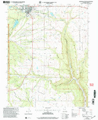
2001 Map of Monticello South
USGS Topo · Published 2004About this map
The town of Monticello sits at the northern edge of this high-plateau landscape, where the agricultural outskirts meet the eastern slopes of the Manti-La Sal National Forest. This 2001 revision illustrates a transitional landscape where municipal utilities like the Sewage Disposal Plant and leisure sites like the Golf Course and Rodeo Grounds give way to the deep, erosion-cut terrain of the Colorado Plateau. To the south, the small settlement of Verdure marks a point of historic habitation near the confluence of Verdure Creek and Montezuma Creek. The geography is defined by significant topographical landmarks such as Dodge Point and the massive Montezuma Canyon, which dominates the eastern half of the sheet. Evidence of land use is visible in the network of pipelines and the various cattle-handling features like the Storage Bin and scattered corals that supported the local ranching economy.
Find a feature on this map
29 named features on this map. Tap any name to fly to it.
Don’t see what you’re looking for? This feature index may not catch every label — zoom into the map to look around manually.
Map Details
Editions of this 2001 Monticello South Map
This is the sole edition of this map. No revisions or reprints were ever made.
Other maps of this area

1886 · Abajo
USGS Topo · 1:250,000

1892 · Abajo
USGS Topo · 1:250,000

1893 · Abajo
USGS Topo · 1:250,000

1955 · Verdure 4 NW
USGS Topo · 1:24,000

1955 · Verdure 2 SE
USGS Topo · 1:24,000

1955 · Verdure 1 SW
USGS Topo · 1:24,000

1955 · Verdure 3 NE
USGS Topo · 1:24,000

1956 · Cortez
USGS Topo · 1:250,000

1957 · Monument Canyon
USGS Topo · 1:62,500

1957 · Blanding
USGS Topo · 1:62,500