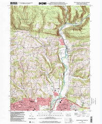
1999 Map of Montoursville North
USGS Topo · Published 2001About this map
Loyalsock Creek carves a central path through this Lycoming County landscape, separating the high elevations of the Tiadaghton State Forest and Blessing Mountain from the expanding suburban fringes of Williamsport. The valley floor is defined by a mix of agricultural history and institutional land use, most notably the Loyalsock State Game Farm and the Lysock View County Home. Along the western edge, the Grampian Hills rise above the city, while small rural clusters like Warrensville and Loyalsockville maintain their distinct identities near the creek's many bends. Genealogists will find a high density of burial sites and historical markers, including Christian Hill Cem, Quaker Hill Cem, and the Ohev Sholom Cemetery. The map captures the transition from the rugged Allegheny Ridge to the residential developments of Kenmar and Faxon at the turn of the millennium.
Find a feature on this map
59 named features on this map. Tap any name to fly to it.
Don’t see what you’re looking for? This feature index may not catch every label — zoom into the map to look around manually.
Map Details
Editions of this 1999 Montoursville North Map
This is the sole edition of this map. No revisions or reprints were ever made.
Other maps of this area

1921 · Williamsport
USGS Topo · 1:48,000

1921 · Trout Run
USGS Topo · 1:62,500

1923 · Trout Run
USGS Topo · 1:62,500

1923 · Williamsport
USGS Topo · 1:62,500

1924 · Milton
USGS Topo · 1:62,500

1930 · Warrensville
USGS Topo · 1:62,500

1934 · Warrensville
USGS Topo · 1:62,500

1944 · Trout Run
USGS Topo · 1:62,500

1944 · Williamsport
USGS Topo · 1:62,500

1953 · Warrensville
USGS Topo · 1:62,500
Featured Places
- Williamsport, PA
- Faxon, Loyalsock Township
- Butternut Grove, Gamble Township
- North Eldred, Eldred Township
- Penn Vale, Loyalsock Township