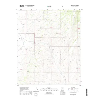
2020 Map of Montoya Butte
USGS Topo · Published 2020About this map
Cibola National Forest encompasses the high desert terrain of this Socorro County landscape, dominated by the prominent volcanic profile of Montoya Butte. The map details a complex drainage system where Alamosa Cr carves through the Monticello Box and Monticello Canyon, a crucial water source in an arid environment. Ranching infrastructure is evident through numerous named water catchments such as Prairie Dog Tank and Elk Tank, reflecting the essential water management required for land use in the Sierra Cuchillo range. This 2020 survey records the intricate network of forest roads, including Forest 140 Rd, that navigate the deep incisions of Kelly Canyon and Sam Hill Canyon. Natural springs like Alum Spring and Ojo Caliente mark vital points of interest for those studying the hydrogeography and historical access points of this remote mountainous region.
Find a feature on this map
40 named features on this map. Tap any name to fly to it.
Don’t see what you’re looking for? This feature index may not catch every label — zoom into the map to look around manually.
Map Details
Editions of this 2020 Montoya Butte Map
This is the sole edition of this map. No revisions or reprints were ever made.
Other maps of this area

1954 · Tularosa
USGS Topo · 1:250,000

1958 · Tularosa
USGS Topo · 1:250,000

1961 · Monticello
USGS Topo · 1:24,000

1964 · Welty Hill
USGS Topo · 1:24,000

1964 · Vicks Peak
USGS Topo · 1:24,000

1964 · Blue Mountain
USGS Topo · 1:24,000

1964 · Montoya Butte
USGS Topo · 1:24,000

1965 · Iron Mountain
USGS Topo · 1:24,000

1965 · Jaralosa Mountain
USGS Topo · 1:24,000

1965 · Dusty
USGS Topo · 1:24,000