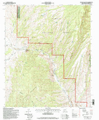
1995 Map of Montoya Butte
USGS Topo · Published 1998About this map
Cibola National Forest encompasses the majority of this high-desert terrain in Socorro County, defined by the sharp convergence of the Cuchillo Mountains and deep drainages like Alamosa Canyon. A significant historical demarcation, the Old Indian Treaty Boundary, cuts through the landscape, separating the forest lands from the adjacent canyons to the west. The presence of Ruins and a Gaging Station near the Monticello Box points to early attempts to manage the scarce water resources of Ojo Caliente Springs and the surrounding draws.
Find a feature on this map
46 named features on this map. Tap any name to fly to it.
Don’t see what you’re looking for? This feature index may not catch every label — zoom into the map to look around manually.
Map Details
Editions of this 1995 Montoya Butte Map
This is the sole edition of this map. No revisions or reprints were ever made.
Other maps of this area

1954 · Tularosa
USGS Topo · 1:250,000

1958 · Tularosa
USGS Topo · 1:250,000

1961 · Monticello
USGS Topo · 1:24,000

1964 · Welty Hill
USGS Topo · 1:24,000

1964 · Vicks Peak
USGS Topo · 1:24,000

1964 · Blue Mountain
USGS Topo · 1:24,000

1964 · Montoya Butte
USGS Topo · 1:24,000

1965 · Iron Mountain
USGS Topo · 1:24,000

1965 · Jaralosa Mountain
USGS Topo · 1:24,000

1965 · Dusty
USGS Topo · 1:24,000