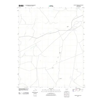
2010 Map of Montoya Point
USGS Topo · Published 2010About this map
Montoya Point stands as the primary landmark in this corner of San Miguel County, overlooking a landscape defined by seasonal watercourses and remote ranching infrastructure. The drainage patterns of the high plains are clearly delineated by the winding paths of La Cinta Creek and Arroyo del Gato, which cut through the terrain. In a region where water management is essential for survival, the placement of isolated landmarks such as the Upper Perra Windmill, Prairie Dog Windmill, and Three Legged Windmill reveals the footprint of local cattle ranching. These small, functional sites are connected by a network of unimproved roads and tracks that follow the natural contours of the land, illustrating the vast distances and specialized land use in this part of northeastern New Mexico during the early 21st century.
Find a feature on this map
8 named features on this map. Tap any name to fly to it.
Don’t see what you’re looking for? This feature index may not catch every label — zoom into the map to look around manually.
Map Details
Editions of this 2010 Montoya Point Map
This is the sole edition of this map. No revisions or reprints were ever made.
Other maps of this area

1954 · Santa Fe
USGS Topo · 1:250,000

1958 · Santa Fe
USGS Topo · 1:250,000

1971 · Canon Encierro
USGS Topo · 1:24,000
1972 · Bell Ranch
USGS Topo · 1:24,000

1972 · Arroyo Alamocito
USGS Topo · 1:24,000

1972 · Montoya Point
USGS Topo · 1:24,000

1972 · Waggoner Ranch
USGS Topo · 1:24,000

1972 · Wade Canyon
USGS Topo · 1:24,000
1972 · Minese Mesa
USGS Topo · 1:24,000
1974 · Solano
USGS Topo · 1:24,000