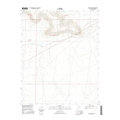
2017 Map of Montoya Point
USGS Topo · Published 2017About this map
Montoya Point rises as a prominent high-desert landmark within this section of the Canadian River basin in eastern New Mexico. The landscape is defined by its drainage systems, most notably the winding course of Arroyo del Gato, which carves through the southern half of the quadrangle. Steep elevation changes are concentrated around the northern escarpment, where Perra Draw and the headwaters of La Cinta Cr provide natural relief against the flat-topped mesas. This 2017 survey reflects the area's continued use as remote ranching territory, with New Mexico State Road 419 serving as the primary corridor for movement through the rugged geography of the Las Vegas Plateau. Local hydrology is further marked by smaller seasonal flows like TV Cr, which punctuate the arid terrain.
Find a feature on this map
10 named features on this map. Tap any name to fly to it.
Don’t see what you’re looking for? This feature index may not catch every label — zoom into the map to look around manually.
Map Details
Editions of this 2017 Montoya Point Map
This is the sole edition of this map. No revisions or reprints were ever made.
Other maps of this area

1954 · Santa Fe
USGS Topo · 1:250,000

1958 · Santa Fe
USGS Topo · 1:250,000

1971 · Canon Encierro
USGS Topo · 1:24,000
1972 · Bell Ranch
USGS Topo · 1:24,000

1972 · Arroyo Alamocito
USGS Topo · 1:24,000

1972 · Montoya Point
USGS Topo · 1:24,000

1972 · Waggoner Ranch
USGS Topo · 1:24,000

1972 · Wade Canyon
USGS Topo · 1:24,000
1972 · Minese Mesa
USGS Topo · 1:24,000
1974 · Solano
USGS Topo · 1:24,000