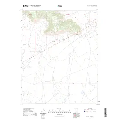
2023 Map of Montoya Point
USGS Topo · Published 2023About this map
Montoya Point rises as a prominent landmark in this San Miguel County landscape, defining the northern high ground where the terrain drops sharply toward the valley floor. The area is marked by a complex system of drainage, with Arroyo del Gato winding across the central plains and Perra Draw cutting through the slopes just south of the point. To the northeast, the waters of La Cinta Creek and Tiv Creek trace their own paths through this arid stretch of New Mexico. This 2023 survey illustrates the modern configuration of rural roads and land boundaries, including parts of t18n r26e and t17n r26e, reflecting a pattern of ranching and land use that remains largely unchanged in its essential character since the early days of settlement.
Find a feature on this map
9 named features on this map. Tap any name to fly to it.
Don’t see what you’re looking for? This feature index may not catch every label — zoom into the map to look around manually.
Map Details
Editions of this 2023 Montoya Point Map
This is the sole edition of this map. No revisions or reprints were ever made.
Other maps of this area

1954 · Santa Fe
USGS Topo · 1:250,000

1958 · Santa Fe
USGS Topo · 1:250,000

1971 · Canon Encierro
USGS Topo · 1:24,000
1972 · Bell Ranch
USGS Topo · 1:24,000

1972 · Arroyo Alamocito
USGS Topo · 1:24,000

1972 · Montoya Point
USGS Topo · 1:24,000

1972 · Waggoner Ranch
USGS Topo · 1:24,000

1972 · Wade Canyon
USGS Topo · 1:24,000
1972 · Minese Mesa
USGS Topo · 1:24,000
1974 · Solano
USGS Topo · 1:24,000