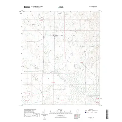
2018 Map of Montpelier
USGS Topo · Published 2018About this map
Montpelier and the surrounding Clay County countryside are defined by a network of creeks and small family cemeteries that trace the area's agricultural heritage. The landscape is heavily marked by the drainage patterns of Sewayiah Creek, Standing Reed Cr, and Little Cane Cr, which historically dictated the placement of homesteads and roads. Genealogists will find significant value in the documentation of local burial grounds, including Old Montpelier Cem, Prairie Creek Cem, and Saint Paul Cem, many of which sit along historic routes like Old Montpelier Rd and Palestine Rd. The presence of Beasley and the landmark at Reid Hill further illustrate the distribution of these small crossroads communities. In the southern portion of the map, the terrain opens into the wetlands surrounding Line Cr and Johnson Cr, eventually reaching Brewer Lake.
Find a feature on this map
59 named features on this map. Tap any name to fly to it.
Don’t see what you’re looking for? This feature index may not catch every label — zoom into the map to look around manually.
Map Details
Editions of this 2018 Montpelier Map
This is the sole edition of this map. No revisions or reprints were ever made.
Other maps of this area

1953 · West Point
USGS Topo · 1:250,000

1958 · West Point
USGS Topo · 1:250,000

1959 · Van Vleet
USGS Topo · 1:62,500

1959 · Pheba
USGS Topo · 1:62,500

1963 · West Point
USGS Topo · 1:250,000

1972 · Maben
USGS Topo · 1:24,000

1972 · Mantee
USGS Topo · 1:24,000
1972 · Woodland
USGS Topo · 1:24,000

1982 · West Point
USGS Topo · 1:100,000

1984 · West Point
USGS Topo · 1:250,000