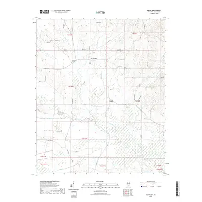
2020 Map of Montpelier
USGS Topo · Published 2020About this map
Montpelier serves as the central community of this Clay County landscape, where the agricultural grid is deeply etched by a network of creeks including Prairie Creek and Standing Reed Creek. The settlement pattern is defined by family-named routes such as Billy Wooten Rd and Ruth Cliett Rd, reflecting long-standing local ties. For genealogists, the map is particularly rich in cemetery data, documenting sites like the Old Montpelier Cem and Palestine Cem that represent the spiritual and ancestral heart of the district.
Find a feature on this map
61 named features on this map. Tap any name to fly to it.
Don’t see what you’re looking for? This feature index may not catch every label — zoom into the map to look around manually.
Map Details
Editions of this 2020 Montpelier Map
This is the sole edition of this map. No revisions or reprints were ever made.
Other maps of this area

1953 · West Point
USGS Topo · 1:250,000

1958 · West Point
USGS Topo · 1:250,000

1959 · Van Vleet
USGS Topo · 1:62,500

1959 · Pheba
USGS Topo · 1:62,500

1963 · West Point
USGS Topo · 1:250,000

1972 · Maben
USGS Topo · 1:24,000

1972 · Mantee
USGS Topo · 1:24,000
1972 · Woodland
USGS Topo · 1:24,000

1982 · West Point
USGS Topo · 1:100,000

1984 · West Point
USGS Topo · 1:250,000