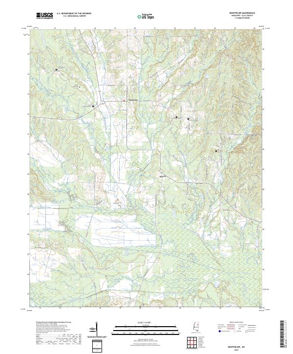
2024 Map of Montpelier
USGS Topo · Published 2024About this map
Montpelier and the nearby community of Beasley anchor this rural Mississippi landscape, where a dense network of country roads connects family-named landmarks and long-established burial grounds. The map reveals a complex drainage system defined by Sewayiah Creek and Line Creek, which meander through low-lying areas in the southern half of the quadrangle. Genealogists will find significant value in the documentation of numerous local cemeteries, including the Old Montpelier Cem, Saint Paul Cem, and Lower Prairie Creek Cem, many of which sit along narrow routes like Old Montpelier Rd and Palestine Rd. The terrain is characterized by subtle elevation changes such as Reid Hill, while the local hydrology is shaped by several tributaries including Standing Reed Creek and Buck Creek. This modern survey maintains the legal framework of the Public Land Survey System, illustrating the township and range lines that have governed land division in Clay County for generations.
Find a feature on this map
63 named features on this map. Tap any name to fly to it.
Don’t see what you’re looking for? This feature index may not catch every label — zoom into the map to look around manually.
Map Details
Editions of this 2024 Montpelier Map
This is the sole edition of this map. No revisions or reprints were ever made.
Other maps of this area

1953 · West Point
USGS Topo · 1:250,000

1958 · West Point
USGS Topo · 1:250,000

1959 · Van Vleet
USGS Topo · 1:62,500

1959 · Pheba
USGS Topo · 1:62,500

1963 · West Point
USGS Topo · 1:250,000

1972 · Maben
USGS Topo · 1:24,000

1972 · Mantee
USGS Topo · 1:24,000
1972 · Woodland
USGS Topo · 1:24,000

1982 · West Point
USGS Topo · 1:100,000

1984 · West Point
USGS Topo · 1:250,000