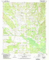
1987 Map of Montpelier
USGS Topo · Published 1987About this map
Montpelier and its surrounding Clay County countryside are defined by a complex network of waterways and a long human history as of the late 1980s. The landscape is bisected by the Old Indian Treaty Boundary, a notable historical line that cuts through the southern portion of the quadrangle near the settlement of Walkers Gin. Water management is central to the area's geography, visible in the engineered pathways of the North Canal and South Canal that flank Line Creek. Educational and spiritual life is concentrated at sites like the West Clay County High Sch, Cairo-Cumberland Ch, and Old Montpelier Ch. This map provides a detailed record of rural Mississippi before modern expansion, capturing the placement of family cemeteries like Cousin Cem and small community landmarks such as the Lighthouse.
Find a feature on this map
31 named features on this map. Tap any name to fly to it.
Don’t see what you’re looking for? This feature index may not catch every label — zoom into the map to look around manually.
Map Details
Editions of this 1987 Montpelier Map
This is the sole edition of this map. No revisions or reprints were ever made.
Other maps of this area

1953 · West Point
USGS Topo · 1:250,000

1958 · West Point
USGS Topo · 1:250,000

1959 · Van Vleet
USGS Topo · 1:62,500

1959 · Pheba
USGS Topo · 1:62,500

1963 · West Point
USGS Topo · 1:250,000

1972 · Maben
USGS Topo · 1:24,000

1972 · Mantee
USGS Topo · 1:24,000
1972 · Woodland
USGS Topo · 1:24,000

1982 · West Point
USGS Topo · 1:100,000

1984 · West Point
USGS Topo · 1:250,000