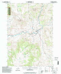
1995 Map of Monument
USGS Topo · Published 1998About this map
The town of Monument sits at the junction of several canyons where the North Fork John Day River and its tributaries carve through the landscape. This 1995 revision reveals a mix of civic infrastructure and remote mountain terrain, featuring a local Cem, a Gaging Station, and a Helipad near the riverbanks. Protective Levee systems follow the water's edge, highlighting the town's relationship with the volatile river. To the north, the Umatilla National Forest occupies the high ground, punctuated by Monument Mountain and its Lookout Tower. Further south, the landscape is defined by family-named canyons and landmarks like Jack of Clubs Creek, Dustin Point, and the steep draws of Hell Canyon. The presence of a Landing Strip and multiple Communications Towers indicates the area's role as a regional hub for forest management and local connectivity in Grant County.
Find a feature on this map
35 named features on this map. Tap any name to fly to it.
Don’t see what you’re looking for? This feature index may not catch every label — zoom into the map to look around manually.
Map Details
Editions of this 1995 Monument Map
This is the sole edition of this map. No revisions or reprints were ever made.
Other maps of this area

1951 · Courtrock
USGS Topo · 1:62,500

1951 · Monument
USGS Topo · 1:62,500

1953 · Kimberly
USGS Topo · 1:62,500

1953 · Picture
USGS Topo · 1:62,500

1955 · Canyon City
USGS Topo · 1:250,000

1959 · Canyon City
USGS Topo · 1:250,000

1980 · Monument
USGS Topo · 1:100,000
1990 · Monument
USGS Topo · 1:24,000
1990 · Miller Flat
USGS Topo · 1:24,000
1990 · Steet Mtn.
USGS Topo · 1:24,000