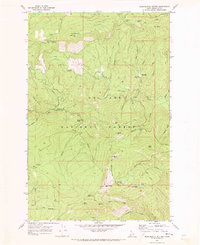
1969 Map of Monumental Buttes
USGS Topo · Published 1973About this map
Roundtop Mtn and its associated Roundtop Work Center anchor this 1969 topographic survey of the Shoshone County backcountry. The landscape is defined by the high ridges of the St Joe National Forest, where a network of primitive transportation routes includes a Jeep Trail and numerous Pack Trails threading between peaks. Historical administrative and safety infrastructure is prominent, marked by a Lookout Tower near the mountain summit, a Radio Facility, and a Heliport.
Find a feature on this map
44 named features on this map. Tap any name to fly to it.
Don’t see what you’re looking for? This feature index may not catch every label — zoom into the map to look around manually.
Map Details
Editions of this 1969 Monumental Buttes Map
This is the sole edition of this map. No revisions or reprints were ever made.
Other maps of this area

1914 · Avery
USGS Topo · 1:125,000

1917 · Avery
USGS Topo · 1:125,000

1923 · Washington Creek
USGS Topo · 1:125,000

1936 · Boehls Butte
USGS Topo · 1:48,000

1943 · Boehls Butte
USGS Topo · 1:62,500

1956 · Wallace
USGS Topo · 1:250,000

1956 · Hamilton
USGS Topo · 1:250,000

1959 · Hamilton
USGS Topo · 1:250,000

1960 · Wallace
USGS Topo · 1:250,000

1960 · Hamilton
USGS Topo · 1:250,000