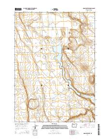
2014 Map of Moon Reservoir
USGS Topo · Published 2014About this map
Silver Creek Valley serves as the central corridor for this arid landscape in Harney County, where seasonal water management is defined by a network of catchments and natural basins. The hydrology of the region is anchored by Moon Reservoir, with numerous smaller features like Antelope Reservoir, Horseshoe Reservoir, and Stinking Lake Reservoir scattered across the basin floors. These names, along with the curious Homestead Hole, point to the historic importance of water access for ranching and settlement in the high desert.
Find a feature on this map
20 named features on this map. Tap any name to fly to it.
Don’t see what you’re looking for? This feature index may not catch every label — zoom into the map to look around manually.
Map Details
Editions of this 2014 Moon Reservoir Map
This is the sole edition of this map. No revisions or reprints were ever made.
Other maps of this area

1955 · Burns
USGS Topo · 1:250,000

1958 · Burns
USGS Topo · 1:250,000

1959 · Burns
USGS Topo · 1:250,000

1979 · Moon Reservoir
USGS Topo · 1:24,000

1980 · Capehart Lake
USGS Topo · 1:24,000

1980 · Iron Mtn. Flat
USGS Topo · 1:24,000

1980 · Stinking Lake
USGS Topo · 1:24,000

1980 · Lake on The Trail
USGS Topo · 1:24,000

1980 · Palomino Buttes
USGS Topo · 1:24,000

1981 · Sage Hen Hill
USGS Topo · 1:24,000