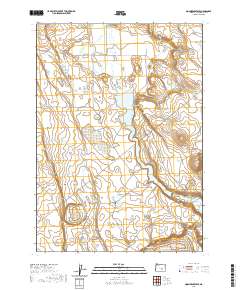
2020 Map of Moon Reservoir
USGS Topo · Published 2020About this map
Silver Creek Valley defines the central geography of this high-desert landscape, where a series of water management features support the arid surroundings. The prominent Moon Reservoir serves as a primary catchment, flanked by the distinct elevation of the Battleground Buttes to the northeast and the long stretch of Coyote Rim to the southwest. This area is characterized by scattered water sources that carry names of local significance, including Antelope Reservoir, Carvix Reservoir, and the curiously named Homestead Hole. Further north, smaller natural water bodies like Rock Lake and Wild Horse Lake punctuate the high ground. The drainage of Silver Creek connects these vital hubs, reflecting the precarious balance of water and land in the Oregon interior.
Find a feature on this map
22 named features on this map. Tap any name to fly to it.
Don’t see what you’re looking for? This feature index may not catch every label — zoom into the map to look around manually.
Map Details
Editions of this 2020 Moon Reservoir Map
This is the sole edition of this map. No revisions or reprints were ever made.
Other maps of this area

1955 · Burns
USGS Topo · 1:250,000

1958 · Burns
USGS Topo · 1:250,000

1959 · Burns
USGS Topo · 1:250,000

1979 · Moon Reservoir
USGS Topo · 1:24,000

1980 · Capehart Lake
USGS Topo · 1:24,000

1980 · Iron Mtn. Flat
USGS Topo · 1:24,000

1980 · Stinking Lake
USGS Topo · 1:24,000

1980 · Lake on The Trail
USGS Topo · 1:24,000

1980 · Palomino Buttes
USGS Topo · 1:24,000

1981 · Sage Hen Hill
USGS Topo · 1:24,000