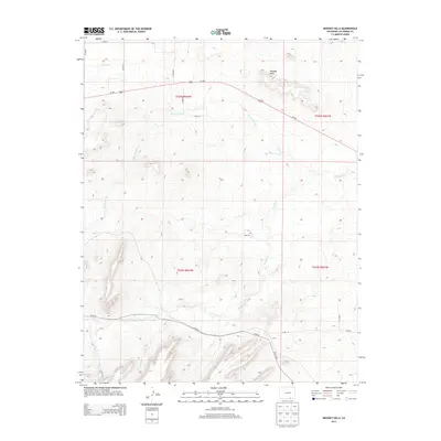
2013 Map of Mooney Hills
USGS Topo · Published 2013About this map
Vigil Cem sits at the heart of this high-plains landscape in Las Animas County, serving as a primary point of historical interest in an area defined by its complex drainage network. The eponymous Mooney Hills dominate the northern terrain, where Us-160 traverses the territory. The map reveals a land heavily shaped by water and elevation, with numerous seasonal watercourses including Patton Arroyo, Frijole Cr, and El Poso Arroyo cutting through the topography. These intermittent streams and the presence of the S Side Ditch suggest a long history of water management in a region where every drop is vital for ranching or agriculture. The road network, primarily composed of county routes like Co RD 22 and Co RD 85, follows the natural contours of the land, connecting family-named landmarks such as Bill Cr and San Miguel Cr.
Find a feature on this map
24 named features on this map. Tap any name to fly to it.
Don’t see what you’re looking for? This feature index may not catch every label — zoom into the map to look around manually.
Map Details
Editions of this 2013 Mooney Hills Map
This is the sole edition of this map. No revisions or reprints were ever made.
Other maps of this area

1892 · Elmoro
USGS Topo · 1:125,000

1893 · Elmoro
USGS Topo · 1:125,000

1897 · Elmoro
USGS Topo · 1:125,000

1954 · Trinidad
USGS Topo · 1:250,000

1955 · Trinidad
USGS Topo · 1:250,000

1958 · Trinidad
USGS Topo · 1:250,000

1959 · Trinidad
USGS Topo · 1:250,000
1970 · Earl
USGS Topo · 1:24,000
1970 · Mooney Hills
USGS Topo · 1:24,000
1970 · Hoehne
USGS Topo · 1:24,000