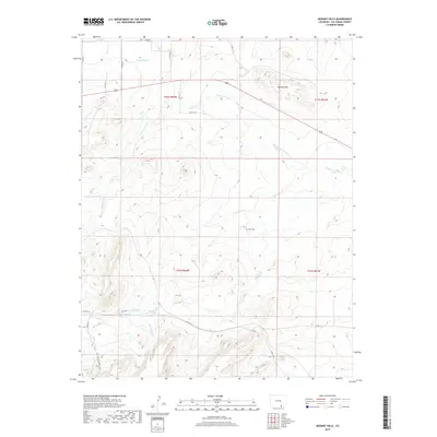
2019 Map of Mooney Hills
USGS Topo · Published 2019About this map
Mooney Hills rise above a landscape defined by an intricate network of drainage systems in this southern Las Animas County terrain. The map traces the winding paths of Patton Arroyo, Frijole Cr, and San Miguel Cr, illustrating the hydrological patterns of the high plains. A lone human landmark, Vigil Cem, stands in the central portion of the quadrangle, serving as a significant point of interest for genealogists and local historians tracing families in this rural corridor. Transportation is represented by a grid of county roads, such as Co RD 85 and Co RD 32.2, alongside the historic San Francisco Pass Trail in the southwest. The presence of the S Side Ditch near the northern boundary indicates managed water use, characteristic of the region's agricultural development.
Find a feature on this map
26 named features on this map. Tap any name to fly to it.
Don’t see what you’re looking for? This feature index may not catch every label — zoom into the map to look around manually.
Map Details
Editions of this 2019 Mooney Hills Map
This is the sole edition of this map. No revisions or reprints were ever made.
Other maps of this area

1892 · Elmoro
USGS Topo · 1:125,000

1893 · Elmoro
USGS Topo · 1:125,000

1897 · Elmoro
USGS Topo · 1:125,000

1954 · Trinidad
USGS Topo · 1:250,000

1955 · Trinidad
USGS Topo · 1:250,000

1958 · Trinidad
USGS Topo · 1:250,000

1959 · Trinidad
USGS Topo · 1:250,000
1970 · Earl
USGS Topo · 1:24,000
1970 · Mooney Hills
USGS Topo · 1:24,000
1970 · Hoehne
USGS Topo · 1:24,000