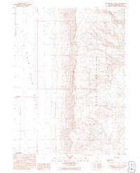
1991 Map of Moonshine Canyon
USGS Topo · Published 1991About this map
The Double H Mountains dominate this high-desert landscape in northern Nevada, rising sharply above the expansive Kings River Valley. At the base of these slopes, the Riverside Ranch marks a pocket of human activity near the southern edge of the Fort Mc Dermitt Indian Reservation. The map details a complex network of seasonal water sources and drainages essential for life in this arid basin, including Moonshine Canyon and Dry Creek.
Find a feature on this map
12 named features on this map. Tap any name to fly to it.
Don’t see what you’re looking for? This feature index may not catch every label — zoom into the map to look around manually.
Map Details
Editions of this 1991 Moonshine Canyon Map
This is the sole edition of this map. No revisions or reprints were ever made.
Other maps of this area

1882 · Paradise
USGS Topo · 1:250,000

1886 · Disaster
USGS Topo · 1:250,000

1893 · Paradise
USGS Topo · 1:250,000

1893 · Disaster
USGS Topo · 1:250,000

1954 · Vya
USGS Topo · 1:250,000

1955 · McDermitt
USGS Topo · 1:250,000

1958 · Vya
USGS Topo · 1:250,000

1958 · Awakening Peak
USGS Topo · 1:62,500

1959 · McDermitt
USGS Topo · 1:250,000

1959 · Orovada
USGS Topo · 1:62,500