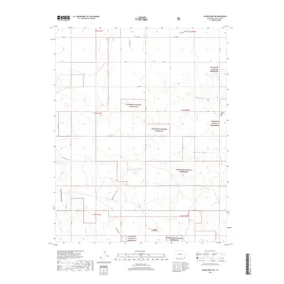
2019 Map of Moore Draw SW
USGS Topo · Published 2019About this map
The high plains of southeast Colorado are defined here by the extensive acreage of the Comanche National Grassland and a network of ephemeral watercourses. This 2019 survey captures a landscape dominated by ranching and history, specifically the path of the Aubry Cutoff - SFHNT, a significant historical trail route that traverses the southwestern portion of the map. The terrain is marked by numerous drainage features such as Moore Draw, Mitchell Draw, and Murray Draw, which carve subtle topography into the prairie. Near the eastern boundary, the Mount Carmel Cem serves as a lone landmark of the area's early settlement. A rigid grid of county roads, including Co RD K and Co RD C, provides the primary access through this open country, illustrating the enduring township and range system that organized the American West.
Find a feature on this map
21 named features on this map. Tap any name to fly to it.
Don’t see what you’re looking for? This feature index may not catch every label — zoom into the map to look around manually.
Map Details
Editions of this 2019 Moore Draw SW Map
This is the sole edition of this map. No revisions or reprints were ever made.
Other maps of this area

1891 · Springfield
USGS Topo · 1:125,000

1892 · Vilas
USGS Topo · 1:125,000

1893 · Springfield
USGS Topo · 1:125,000

1954 · Dalhart
USGS Topo · 1:250,000

1955 · La Junta
USGS Topo · 1:250,000

1958 · La Junta
USGS Topo · 1:250,000

1958 · Dalhart
USGS Topo · 1:250,000

1962 · Dalhart
USGS Topo · 1:250,000

1968 · La Junta
USGS Topo · 1:250,000
1969 · Razor Blade Mesa
USGS Topo · 1:24,000