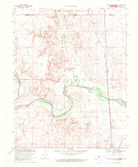
1969 Map of Razor Blade Mesa
USGS Topo · Published 1971About this map
The Cimarron River carves a deep valley through this Oklahoma Panhandle landscape, where the high plains of Comanche National Grassland meet the rugged terrain of Cimarron County. The topography is defined by prominent landforms such as Razor Blade Mesa, Sugarloaf Mountain, and Winchester Mesa, which rise sharply above the riverbed and its surrounding tributaries like Aubury Creek and Cold Springs Creek.
Find a feature on this map
18 named features on this map. Tap any name to fly to it.
Don’t see what you’re looking for? This feature index may not catch every label — zoom into the map to look around manually.
Map Details
Editions of this 1969 Razor Blade Mesa Map
This is the sole edition of this map. No revisions or reprints were ever made.
Other maps of this area

1891 · Springfield
USGS Topo · 1:125,000

1892 · Vilas
USGS Topo · 1:125,000

1893 · Springfield
USGS Topo · 1:125,000

1954 · Dalhart
USGS Topo · 1:250,000

1955 · La Junta
USGS Topo · 1:250,000

1958 · La Junta
USGS Topo · 1:250,000

1958 · Dalhart
USGS Topo · 1:250,000

1962 · Dalhart
USGS Topo · 1:250,000

1968 · La Junta
USGS Topo · 1:250,000

1968 · Autograph Cliff NW
USGS Topo · 1:24,000