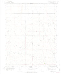
1978 Map of Moore Draw SW
USGS Topo · Published 1978About this map
The high plains of Baca County are defined by a network of ephemeral watercourses, most notably Moore Draw, which cut through the southeastern Colorado landscape. This 1970s landscape shows evidence of sparse settlement and agricultural infrastructure, centered around the locale of Lowder. Genealogy researchers will find Mt Carmel Cem and the nearby Radio Tower in the eastern portion of the quadrangle, serving as distinct landmarks in the open terrain. The drainage patterns of Mitchell Draw and Murray Draw illustrate the natural topography that dictated early land use. Industrial activity is documented through numerous Drill Hole locations and Gravel Pits, along with a Gas Well in the southern reaches near Burrows Draw. These labels provide a record of the mid-to-late 20th-century resource extraction and livestock-supporting infrastructure in this part of the state.
Find a feature on this map
14 named features on this map. Tap any name to fly to it.
Don’t see what you’re looking for? This feature index may not catch every label — zoom into the map to look around manually.
Map Details
Editions of this 1978 Moore Draw SW Map
This is the sole edition of this map. No revisions or reprints were ever made.
Other maps of this area

1891 · Springfield
USGS Topo · 1:125,000

1892 · Vilas
USGS Topo · 1:125,000

1893 · Springfield
USGS Topo · 1:125,000

1954 · Dalhart
USGS Topo · 1:250,000

1955 · La Junta
USGS Topo · 1:250,000

1958 · La Junta
USGS Topo · 1:250,000

1958 · Dalhart
USGS Topo · 1:250,000

1962 · Dalhart
USGS Topo · 1:250,000

1968 · La Junta
USGS Topo · 1:250,000
1969 · Razor Blade Mesa
USGS Topo · 1:24,000