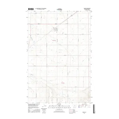
2017 Map of Moore
USGS Topo · Published 2017About this map
Moore serves as the central hub for this portion of Fergus County, situated at the intersection of Fergus Ave and 1st Ave N. The landscape reflects a structured agricultural grid defined by the Public Land Survey System, specifically t14n r16e and t13n r16e, where local roads often follow section lines. Water resources are critical in this high-plains environment, with drainages such as Little Trout Cr, Olsen Cr, and Dawkins Br carving through the terrain. Evidence of early land use and settlement is found at Dawkins Springs and the Moore Cem, which remains a key genealogical landmark for the community. The network of rural routes, including Sipple Rd and Ross Fork Rd, provides a clear view of the property divisions and access points that have sustained the ranching and farming operations in this part of Montana for generations.
Find a feature on this map
31 named features on this map. Tap any name to fly to it.
Don’t see what you’re looking for? This feature index may not catch every label — zoom into the map to look around manually.
Map Details
Editions of this 2017 Moore Map
This is the sole edition of this map. No revisions or reprints were ever made.
Other maps of this area

1889 · Big Snowy Mountain
USGS Topo · 1:250,000

1893 · Big Snowy Mountain
USGS Topo · 1:250,000

1954 · Roundup
USGS Topo · 1:250,000

1954 · Lewistown
USGS Topo · 1:250,000

1958 · Roundup
USGS Topo · 1:250,000

1959 · Lewistown
USGS Topo · 1:250,000
1970 · Buffalo
USGS Topo · 1:24,000

1970 · Glengarry
USGS Topo · 1:24,000

1970 · Crystal Lake
USGS Topo · 1:24,000

1970 · Moore
USGS Topo · 1:24,000