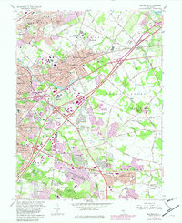
1966 Map of Moorestown
USGS Topo · Published 1982About this map
The suburban landscape of Burlington County is captured here during a period of rapid development, where established agricultural hamlets and historic centers meet the expanding infrastructure of the mid-20th century. The New Jersey Turnpike and the Conrail rail line cut across the terrain, shaping the growth of communities like Moorestown, Maple Shade, and Cherry Hill. Despite the encroaching residential density seen in developments such as Kingston Estates and Ramblewood, the map preserves the locations of older landmarks like the Colestown Cemetery and the Cistercian Monastery. The transition from rural to suburban is evident in the presence of the Moorestown Mall Shopping Center alongside traditional sites like Strawbridge Lake and the Wiley Mission. From the heights of Mount Laurel down to the banks of the North Branch Pennsauken Creek, this survey documents the integration of new transit corridors into the existing local geography of churches, cemeteries, and schools.
Find a feature on this map
92 named features on this map. Tap any name to fly to it.
Don’t see what you’re looking for? This feature index may not catch every label — zoom into the map to look around manually.
Map Details
Editions of this 1966 Moorestown Map
Other maps of this area

1888 · Mount Holly
USGS Topo · 1:62,500

1890 · Burlington
USGS Topo · 1:62,500

1891 · Philadelphia
USGS Topo · 1:62,500

1893 · Germantown
USGS Topo · 1:62,500

1893 · Burlington
USGS Topo · 1:62,500

1894 · Mount Holly
USGS Topo · 1:62,500

1894 · Philadelphia
USGS Topo · 1:62,500

1894 · Germantown
USGS Topo · 1:62,500

1896 · Germantown
USGS Topo · 1:62,500

1896 · Philadelphia
USGS Topo · 1:62,500
Featured Places
- Cherry Hill Township, NJ
- Mount Laurel Township, NJ
- Willingboro Township, NJ
- Moorestown Township, NJ
- Maple Shade Township, NJ