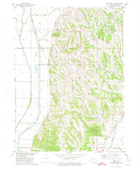
1971 Map of Moorhead NW
USGS Topo · Published 1974About this map
Preparation Canyon State Park anchors the southeastern portion of this terrain, where the Missouri River Basin development program documented the sharp transition from the flat bottomlands of the Little Sioux River to the complex ridges of the Loess Hills. The mapping illustrates an intricate hydrological network where Beaver Creek and Cottonwood Creek meet the valley floor, controlled by a system of levees and gaging stations. Cultural landmarks are scattered throughout the elevated townships of Belvidere, Jordan, and Spring Valley, including the Ingemann Ch and remote burial sites like Bethesda Cem. The southern edge is defined by the course of the Soldier River and its confluence with Hall Creek, providing a detailed look at the rural landscape and drainage patterns of Monona County in the early 1970s.
Find a feature on this map
18 named features on this map. Tap any name to fly to it.
Don’t see what you’re looking for? This feature index may not catch every label — zoom into the map to look around manually.
Map Details
Editions of this 1971 Moorhead NW Map
This is the sole edition of this map. No revisions or reprints were ever made.
Other maps of this area

1954 · Omaha
USGS Topo · 1:250,000

1954 · Fort Dodge
USGS Topo · 1:250,000

1955 · Sioux City
USGS Topo · 1:250,000

1955 · Fremont
USGS Topo · 1:250,000

1957 · Fremont
USGS Topo · 1:250,000

1957 · Omaha
USGS Topo · 1:250,000

1957 · Fort Dodge
USGS Topo · 1:250,000

1958 · Sioux City
USGS Topo · 1:250,000

1958 · Omaha
USGS Topo · 1:250,000

1958 · Fremont
USGS Topo · 1:250,000