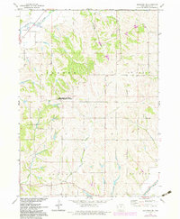
1971 Map of Mapleton SE
USGS Topo · Published 1983About this map
The Maple River valley and its surrounding uplands characterize this 1971 survey of Monona County, illustrating the agrarian and educational landscape of the period. A prominent landmark is the Iowa State University Western Research Center, which stands as a hub for regional agricultural study. The terrain is deeply carved by watercourses including McCleery Creek, Jordan Creek, and Beaver Creek, all feeding into the larger river systems that defined the local drainage and land use before late-century developments. Local genealogy is anchored by several rural burial grounds such as Center Cem in the north and Jordan Cem near the southern boundary. To the southeast, the Soldier River cuts across the corner of the sheet, providing another significant riparian corridor. Evidence of local industry is sparse but present in the form of a Gravel Pit, reflecting the extraction of glacial deposits common to this part of Iowa.
Find a feature on this map
15 named features on this map. Tap any name to fly to it.
Don’t see what you’re looking for? This feature index may not catch every label — zoom into the map to look around manually.
Map Details
Editions of this 1971 Mapleton SE Map
2 editions found
Other maps of this area

1954 · Omaha
USGS Topo · 1:250,000

1954 · Fort Dodge
USGS Topo · 1:250,000

1957 · Omaha
USGS Topo · 1:250,000

1957 · Fort Dodge
USGS Topo · 1:250,000

1958 · Omaha
USGS Topo · 1:250,000

1958 · Fort Dodge
USGS Topo · 1:250,000

1969 · Danbury
USGS Topo · 1:24,000

1969 · Mapleton
USGS Topo · 1:24,000

1969 · Castana
USGS Topo · 1:24,000
1969 · Smithland
USGS Topo · 1:24,000