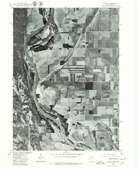
1977 Map of Albaton
USGS Topo · Published 1979About this map
The Missouri River defines the western edge of this landscape, its winding course carving through the fertile bottomlands of Monona County. This orthophotoquad, derived from 1977 aerial photography, offers a clear visual record of the agricultural grid that dominates the region east of the river. The small settlement of Albaton sits centrally amidst this patchwork of cultivated fields, serving as a focal point for the surrounding rural community. Produced in cooperation with the Bureau of Indian Affairs, the map highlights the stark geometry of late-twentieth-century industrial farming contrasted against the natural, shifting curves of the riverbank and its associated sandbars and riparian vegetation.
Find a feature on this map
2 named features on this map. Tap any name to fly to it.
Don’t see what you’re looking for? This feature index may not catch every label — zoom into the map to look around manually.
Map Details
Editions of this 1977 Albaton Map
This is the sole edition of this map. No revisions or reprints were ever made.
Other maps of this area

1955 · Sioux City
USGS Topo · 1:250,000

1958 · Sioux City
USGS Topo · 1:250,000

1959 · Sioux City
USGS Topo · 1:250,000

1964 · Luton
USGS Topo · 1:24,000

1964 · Homer
USGS Topo · 1:24,000

1964 · Salix
USGS Topo · 1:24,000

1966 · Walthill SW
USGS Topo · 1:24,000

1966 · Walthill
USGS Topo · 1:24,000

1966 · Macy
USGS Topo · 1:24,000

1969 · Albaton
USGS Topo · 1:24,000