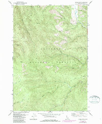
1987 Map of Moose Butte
USGS Topo · Published 1987About this map
Nez Perce National Forest defines the character of this Idaho backcountry, where the Red River and its numerous forks carve through a complex drainage system. The presence of the Old Portland Mine in the northern reaches of the quadrangle points to the region's prospecting history, tucked between steep ridges and high summits like Porters Mtn. The landscape is dominated by heavy timber and sharp elevation changes, with peaks such as Moose Butte and Jack Mtn overlooking a network of named waters including Moose Meadow Creek and Relief Cr. While much of the area is accessible only by Jeep Trail, the map details the intricate hydrography of the South Fork Red River and Middle Fork Red River, reflecting a wilderness where resource extraction and forest management represent the primary human footprints.
Find a feature on this map
26 named features on this map. Tap any name to fly to it.
Don’t see what you’re looking for? This feature index may not catch every label — zoom into the map to look around manually.
Map Details
Editions of this 1987 Moose Butte Map
This is the sole edition of this map. No revisions or reprints were ever made.
Other maps of this area

1931 · Buffalo Hump
USGS Topo · 1:125,000

1934 · Buffalo Hump
USGS Topo · 1:125,000

1956 · Elk City
USGS Topo · 1:250,000

1960 · Elk City
USGS Topo · 1:250,000

1962 · Center Star Mtn
USGS Topo · 1:24,000

1966 · Elk City
USGS Topo · 1:24,000

1966 · Black Hawk Mtn
USGS Topo · 1:24,000

1977 · Silver Spur Ridge
USGS Topo · 1:24,000

1978 · Moose Butte
USGS Topo · 1:24,000

1978 · Trapper Creek
USGS Topo · 1:24,000