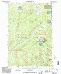
1996 Map of Moose Lake
USGS Topo · Published 1998About this map
Lone Pine Ridge dominates the central terrain of this mountain landscape, which is largely defined by the protected lands of the Deerlodge National Forest. In the late 20th century, this area remained a high-altitude sanctuary for miners and outdoorsmen, evidenced by the presence of the Banner Mine and Old Dominion Mine situated near the headwaters of the Middle Fork Rock Creek. The map shows a clear distinction between the rugged drainages like Copper Creek and the gentler openings of Zekes Meadows and Moose Meadow Creek. Small alpine waters including Kaiser Lake and Whetstone Lake are scattered across the slopes, while the southeastern corner enters the high peaks of the Anaconda Pintler Wilderness. Human presence is minimal and seasonal, centered around the Moose Lake Rental Cabin near the shoreline of Moose Lake.
Find a feature on this map
28 named features on this map. Tap any name to fly to it.
Don’t see what you’re looking for? This feature index may not catch every label — zoom into the map to look around manually.
Map Details
Editions of this 1996 Moose Lake Map
This is the sole edition of this map. No revisions or reprints were ever made.
Other maps of this area

1908 · Philipsburg
USGS Topo · 1:125,000

1909 · Sapphire
USGS Topo · 1:125,000

1947 · Butte
USGS Topo · 1:250,000

1955 · Dillon
USGS Topo · 1:250,000

1957 · Dillon
USGS Topo · 1:250,000

1958 · Butte
USGS Topo · 1:250,000

1958 · Dillon
USGS Topo · 1:250,000

1960 · Butte
USGS Topo · 1:250,000

1962 · Butte
USGS Topo · 1:250,000

1962 · Dillon
USGS Topo · 1:250,000