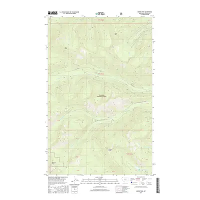
2017 Map of Moose Peak
USGS Topo · Published 2017About this map
Moran Peak and Moose Peak dominate this section of the Whitefish Range, where the steep drainages of the Flathead National Forest define the landscape. This 2017 survey details a network of timber and access routes, including Coal Creek Rd and Natl Forest Develop Road 317 Rd, which wind through the elevations of Coal Ridge. The map captures a high-altitude wilderness defined by its complex hydrology, from the headwaters of S Fork Coal Cr to the remote Moose Lake. The drainage patterns of Moran Cr and Cyclone Cr illustrate the primary corridors through this protected forest land, highlighting the intersection of forest management infrastructure and the natural terrain of Flathead County.
Find a feature on this map
19 named features on this map. Tap any name to fly to it.
Don’t see what you’re looking for? This feature index may not catch every label — zoom into the map to look around manually.
Map Details
Editions of this 2017 Moose Peak Map
This is the sole edition of this map. No revisions or reprints were ever made.
Other maps of this area

1906 · Kintla Lakes
USGS Topo · 1:125,000

1913 · Stryker
USGS Topo · 1:125,000

1916 · Stryker
USGS Topo · 1:125,000

1938 · Kintla Lakes
USGS Topo · 1:125,000

1957 · Kalispell
USGS Topo · 1:250,000

1960 · Kalispell
USGS Topo · 1:250,000

1961 · Kalispell
USGS Topo · 1:250,000

1966 · Red Meadow Lake
USGS Topo · 1:24,000
1966 · Olney
USGS Topo · 1:24,000
1966 · Skookoleel Creek
USGS Topo · 1:24,000