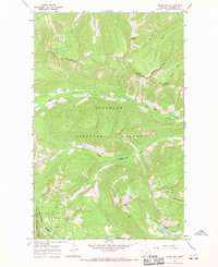
1966 Map of Moose Peak
USGS Topo · Published 1971About this map
Flathead National Forest dominates this mid-1960s topographic survey, where high ridges and deep drainages define the landscape of the Whitefish Range. The Coal Ridge Lookout Tower stands as a sentinel atop Coal Ridge, a critical vantage point for forest management and fire detection during this era. The terrain is characterized by steep elevation changes, ranging from the heights of Moran Peak and Moose Peak down to the narrow valley floors. A network of primitive transportation, including a Pack Trail and Jeer Trail, provides the only access through this backcountry. Numerous drainages such as Mathias Creek, Dead Horse Creek, and Kletomus Creek feed into larger systems like Coal Creek. Near the southern boundary, Moose Lake serves as a prominent water feature amidst the dense contours of the Stillwater State Forest.
Find a feature on this map
20 named features on this map. Tap any name to fly to it.
Don’t see what you’re looking for? This feature index may not catch every label — zoom into the map to look around manually.
Map Details
Editions of this 1966 Moose Peak Map
This is the sole edition of this map. No revisions or reprints were ever made.
Other maps of this area

1906 · Kintla Lakes
USGS Topo · 1:125,000

1913 · Stryker
USGS Topo · 1:125,000

1916 · Stryker
USGS Topo · 1:125,000

1938 · Kintla Lakes
USGS Topo · 1:125,000

1957 · Kalispell
USGS Topo · 1:250,000

1960 · Kalispell
USGS Topo · 1:250,000

1961 · Kalispell
USGS Topo · 1:250,000

1966 · Red Meadow Lake
USGS Topo · 1:24,000
1966 · Olney
USGS Topo · 1:24,000
1966 · Skookoleel Creek
USGS Topo · 1:24,000