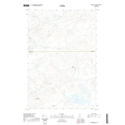
2021 Map of Mooseleuk Lake
USGS Topo · Published 2021About this map
Mooseleuk Lake serves as the focal point for this wilderness drainage system in northern Maine, where the boundary between Aroostook and Piscataquis counties bisects a landscape of ponds and deadwaters. The topography is defined by the Mule Brook Mountains and Spring Brook Hill, which steer a network of brooks toward the Mooseleuk Stream. Significant water features like McNally Deadwater, Lower Deadwater Pond, and Mink Marsh Pond indicate a low-gradient, marshy environment vital to the local ecosystem. While largely undeveloped, the presence of Realty Rd and Jack Mtn Rd provides evidence of the logging infrastructure and backcountry access routes that have historically shaped this timber-producing region.
Find a feature on this map
26 named features on this map. Tap any name to fly to it.
Don’t see what you’re looking for? This feature index may not catch every label — zoom into the map to look around manually.
Map Details
Editions of this 2021 Mooseleuk Lake Map
This is the sole edition of this map. No revisions or reprints were ever made.
Other maps of this area

1931 · Mooseleuk Lake
USGS Topo · 1:48,000

1932 · Musquacook Lakes
USGS Topo · 1:48,000

1935 · Musquacook Lakes
USGS Topo · 1:62,500

1935 · Mooseleuk Lake
USGS Topo · 1:62,500

1954 · Spider Lake
USGS Topo · 1:62,500

1954 · Millinocket Lake
USGS Topo · 1:62,500

1954 · Presque Isle
USGS Topo · 1:250,000

1958 · Presque Isle
USGS Topo · 1:250,000

1960 · Presque Isle
USGS Topo · 1:250,000

1961 · Spider Lake
USGS Topo · 1:62,500