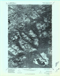
1975 Map of Mooseleuk Lake SW
USGS Topo · Published 1981About this map
Mooseleuk Lake anchors the southeastern corner of this orthophotoquad, which utilizes aerial imagery taken in late October 1975 to document the unorganized territory of north-central Maine. The landscape is defined by the complex water systems of the North Woods, including Big Hudson Brook and Spring Brook, which weave through a terrain marked by prominent elevations like Bartlett Mountain and the Rocky Mts. Unlike traditional topographic maps, this imagery provides a visual record of forest density and natural clearings surrounding Mc Pherson Pond and Rocky Brook. The lack of named roads or buildings underscores the remote timber-producing character of this region during the mid-1970s, making it a valuable tool for understanding the undisturbed drainage patterns and landforms of the Piscataquis wilderness before modern forest management or development altered the visible canopy.
Find a feature on this map
8 named features on this map. Tap any name to fly to it.
Don’t see what you’re looking for? This feature index may not catch every label — zoom into the map to look around manually.
Map Details
Editions of this 1975 Mooseleuk Lake SW Map
This is the sole edition of this map. No revisions or reprints were ever made.
Other maps of this area

1931 · Mooseleuk Lake
USGS Topo · 1:48,000

1932 · Musquacook Lakes
USGS Topo · 1:48,000

1935 · Musquacook Lakes
USGS Topo · 1:62,500

1935 · Mooseleuk Lake
USGS Topo · 1:62,500

1954 · Spider Lake
USGS Topo · 1:62,500

1954 · Millinocket Lake
USGS Topo · 1:62,500

1954 · Presque Isle
USGS Topo · 1:250,000

1958 · Presque Isle
USGS Topo · 1:250,000

1960 · Presque Isle
USGS Topo · 1:250,000

1961 · Spider Lake
USGS Topo · 1:62,500