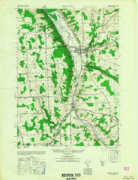
1949 Map of Moravia
USGS Topo · Published 1949About this map
Owasco Inlet carves a central corridor through the Finger Lakes region in this post-war landscape, providing a natural path for the Lehigh Valley railroad. The village of Moravia serves as the primary hub, where Mill Creek meets the flats just south of Owasco Lake. The area's agricultural and social fabric is clearly defined by a dense network of numbered schoolhouses, from School No 1 to School No 9, and local crossroads like Rafferty Corners and Satterly Corners.
Find a feature on this map
52 named features on this map. Tap any name to fly to it.
Don’t see what you’re looking for? This feature index may not catch every label — zoom into the map to look around manually.
Map Details
Editions of this 1949 Moravia Map
This is the sole edition of this map. No revisions or reprints were ever made.
Other maps of this area

1898 · Moravia
USGS Topo · 1:62,500

1899 · Auburn
USGS Topo · 1:62,500

1899 · Skaneateles
USGS Topo · 1:62,500

1902 · Skaneateles
USGS Topo · 1:62,500

1902 · Moravia
USGS Topo · 1:62,500

1902 · Genoa
USGS Topo · 1:62,500

1902 · Auburn
USGS Topo · 1:62,500

1942 · Ludlowville
USGS Topo · 1:24,000

1942 · Groton
USGS Topo · 1:24,000

1942 · Genoa
USGS Topo · 1:24,000