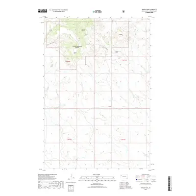
2017 Map of Moreau Peak
USGS Topo · Published 2017About this map
Moreau Peak stands as a prominent landmark within the Custer National Forest, dominating a landscape defined by the drainage systems of the East Short Pine Hills. This corner of Harding County exhibits a complex network of topographical features, where deep ravines like Adams Gulch, Coal Gulch, and Ward Gulch carve through the high ground. The naming of these gulches often hints at early resource extraction or local family history, providing clues for researchers of the region's land use. Hydrological patterns are established by the intermittent flows of Sand Creek and South Sand Creek, which traverse the lower elevations. The map documents a sparsely populated area where travel is dictated by established routes like Dillon Road and Dunn Road, which skirt the edges of the national forest boundaries and connect the open ranges of the high plains.
Find a feature on this map
19 named features on this map. Tap any name to fly to it.
Don’t see what you’re looking for? This feature index may not catch every label — zoom into the map to look around manually.
Map Details
Editions of this 2017 Moreau Peak Map
This is the sole edition of this map. No revisions or reprints were ever made.
Other maps of this area

1935 · Harding
USGS Topo · 1:125,000

1954 · Lemmon
USGS Topo · 1:250,000

1957 · Lemmon
USGS Topo · 1:250,000

1973 · Lone Tree Draw West
USGS Topo · 1:24,000

1973 · Bog Creek
USGS Topo · 1:24,000

1973 · Redig
USGS Topo · 1:24,000

1973 · Hells Canyon
USGS Topo · 1:24,000
1977 · Harding
USGS Topo · 1:24,000
1978 · Redig NE
USGS Topo · 1:24,000
1978 · Alkali Creek West
USGS Topo · 1:24,000