1978 Map of Redig NE
USGS Topo · Published 1978About this map
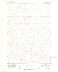
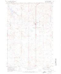
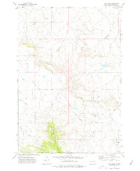
Northwestern South Dakota's high plains landscape is defined by the complex drainage systems of the North Fork Moreau River and its numerous tributaries. This late 1970s survey captures a vast section of Harding County dominated by the Clarks Fork Creek and Buffalo Creek watersheds. The map reflects a sparsely populated ranching environment where water sources are paramount, marked specifically by intermittent streams and a solitary Well near the center of the sheet. Modern infrastructure is represented by the north-south corridor of Route 85, which cuts through the rolling topography of the Diamond area. In the southern portion of the quadrangle, the South Branch Duck Creek begins its eastward traverse, illustrating the subtle but critical divides that govern water flow across this semiarid range land.
Find a feature on this map
7 named features on this map. Tap any name to fly to it.
Don’t see what you’re looking for? This feature index may not catch every label — zoom into the map to look around manually.
Map Details
Editions of this 1978 Redig NE Map
This is the sole edition of this map. No revisions or reprints were ever made.
Other maps of this area

1935 · Reva
USGS Topo · 1:125,000

1935 · Hoover
USGS Topo · 1:125,000

1935 · Harding
USGS Topo · 1:125,000

1935 · Buffalo
USGS Topo · 1:125,000

1954 · Lemmon
USGS Topo · 1:250,000

1957 · Lemmon
USGS Topo · 1:250,000
1971 · Buffalo
USGS Topo · 1:24,000
1971 · Sheep Pen Draw SW
USGS Topo · 1:24,000
1971 · Saddle Butte
USGS Topo · 1:24,000
1973 · Bog Creek
USGS Topo · 1:24,000