Loading...
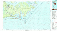
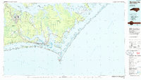
Loading map...1990 Map of Morehead City
USGS Topo · Published 1990About this map
Cherry Point Marine Corps Air Station and the deep woods of the Croatan National Forest anchor the western reaches of this 1990 coastal study. The landscape is defined by the meeting of the Neuse River and the complex sounds that separate the mainland from the Outer Banks. Major coastal hubs like Morehead City and Beaufort are mapped alongside a string of barrier island communities, including Atlantic Beach, Pine Knoll Shores, and Indian Beach.
Find a feature on this map
114 named features on this map. Tap any name to fly to it.
Don’t see what you’re looking for? This feature index may not catch every label — zoom into the map to look around manually.
Map Details
Date Portrayed1990
Date Published1990
PublisherU.S. Geological Survey
Map TypeTopographic
Scale1:100,000
Physical Dimensions43.5 x 24.1 inches
Editions of this 1990 Morehead City Map
This is the sole edition of this map. No revisions or reprints were ever made.
Historical Maps of New Bern Through Time
Featured Locations
Source Details
SourceU.S. Geological Survey
CopyrightPublic Domain